Overview
Digital Twin (DT) technology represents the next evolution in a gradual shift from physical to digital models in civil engineering. Computer-Aided Drafting (CAD) revolutionized the industry by reducing the time and costs associated with documenting the design. Building Information Modeling (BIM) has since all but eliminated the need for physical design descriptors (i.e., drawings or physical models).A digital twin is a relevant abstraction of the physical asset. It is most frequently used to model/improve/control manufacturing systems. Civil engineering applications of DT have been starting to emerge, but transportation infrastructure represents a challenging extension of DT technology because of its spatial scale and voluminous and time-varying data. However, DT is a powerful decision support tool for the design, maintenance, and management of transportation infrastructure, particularly for studying the interdependency with other infrastructure systems.
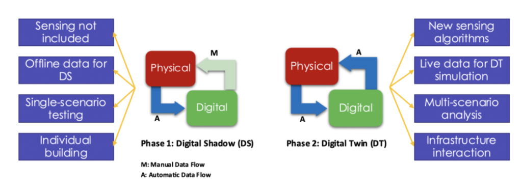
This project is a continuation of a C2SMART funded project from 2021 titled “Digital Twin Technologies Towards Understanding the Interactions between Transportation and other Civil Infrastructure Systems.” In the phase 1 project, the team built a digital shadow of campus civil infrastructure and visualized impacts of construction project schedule on the surrounding transportation infrastructure. Phase 2 is focused on expanding the phase 1 project in three aspects: (1) extends the digital twin (DT) model from a building to multiple representative locations on a campus; (2) instead of using historical data to build an offline digital shadow, phase 2 will develop a Smart Living Lab (SLL), which enables live data streams from three selected sites on campus via sensor instrumentation, data communication, and database design; and (3) demonstrate a working prototype of digital twin, the SLL will be integrated with the digital model (DM) for real-time scenarios analysis, infrastructure interactions, and decision-making.
Research Objectives
The primary objective of this research is to explore the effectiveness of DT technology as a tool to understand interactions between transportation and other civil infrastructure systems. For example, simulating the timing plan to respond to real-time traffic conditions to better manage traffic on campus (practical implication: intersections on campus are fixed-timed, the interaction of traffic and the infrastructure help improve signal timing plans regarding timeliness and efficiency); studying the data correlations among the three infrastructure sites on campus (practical implication: the relationships between different campus infrastructures through data analysis and simulation help better understand campus operations).
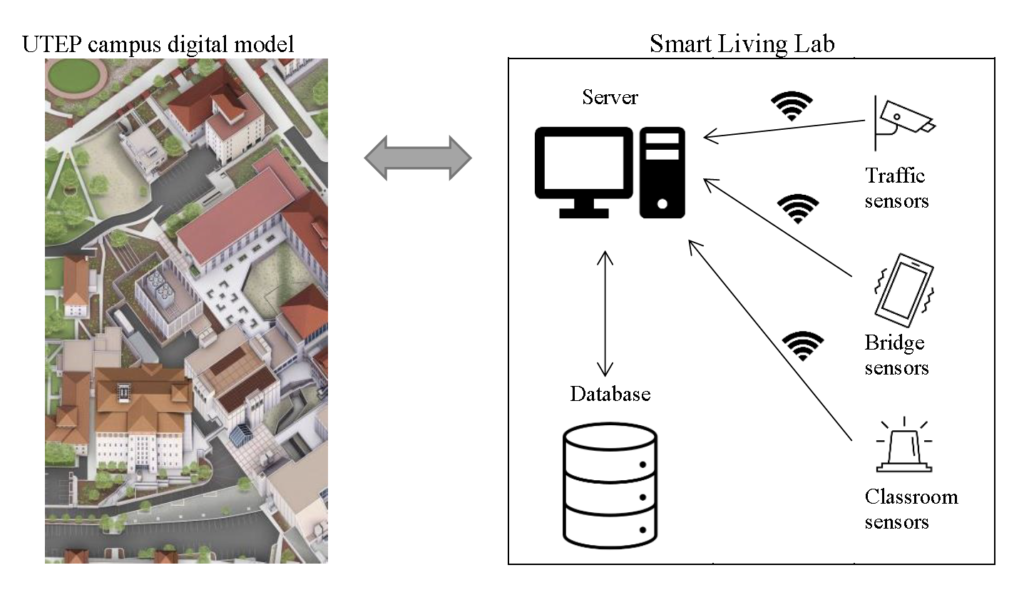
An SLL will be created on campus to include at least three sites with real-time data streams to enable DT applications. The concept of the SLL is shown in Figure 2. The tentative plan includes a pedestrian bridge, a parking garage or a signalized intersection, and a classroom. Sensors will be installed at each site for live data collection to the project server. Data communication will be through the campus network. Digital replicas of these sites will be built on simulation platforms on the server. They will link with the databases that store the data streamed from the test sites. Specifically, the project will:
- Summarize the most recent literature around DT in transportation and civil infrastructures and provide an update of the state of adoption.
- Collect LiDAR point cloud data to build the digital model (DM) of the expanded areas of campus infrastructures (including buildings, roads, parking facilities, and bridges).
- Identify at least three sites with infrastructure operations of interest to the campus community. These three sites will include a classroom, a bridge, and an intersection or parking garage.
- Identify data collection needs, select sensors, and processing units, and then develop sensing methods for test sites.
- Design data communications methods and databases on the project server.
- Develop digital replica and simulation models of the test sites.
- Conduct analysis to understand standalone operations and the interactions between different transportation and civil infrastructures through the DT models.
- Disseminate the results and findings through public outreach and scholarly activities.
Additionally, the team will integrate the Project with the undergraduate and graduate courses (e.g., Senior Design Capstone, Smart City Design) at UTEP to expose civil engineering students to emerging technologies like LiDAR for reality capture, BIM modeling, traffic simulation, transportation data science, and DT.
Related Media


