C2SMARTER Student Learning Hub

What is the Student Learning Hub?

In the fall of 2020, C2SMART (now C2SMARTER) launched the Student Learning Hub, free for all consortium member students. Students are able to access learning from a variety of course domains, including data science, computer science, and traffic simulation.

The Hub is designed to offer students hands-on experience to learn the tools and skills they will need as they advance their careers, whether in academia, industry, or within government agencies. 

To accomplish this, the Hub operates using four primary pillars of work:

Community

Skill Building

Applied Learning

Job Preparation

This Semester’s Courses and Recordings

  • Instructors: Tu Lan & Vivaldi Rinaldi, NYU
  • Beginner level: No prior experience required. 
  • Schedule: Friday, October 11, 1:00 pm – 2:00 pm ET
  • Description: Drones are becoming an invaluable tool for urban data collection, offering a wide range of applications from traffic monitoring to environmental analysis. This course introduces participants to the full scope of using drones for traffic data collection, starting with the necessary FAA licensing and airspace regulations, followed by practical guidance on drone operation and control. We’ll explore the different sensors and gimbals that can be equipped on drones, such as cameras, thermal imaging, and LiDAR, and their respective applications in collecting urban data. This session provides a comprehensive understanding of how drones can be utilized for diverse data-driven urban analyses.
  • Recording Link: Here.
  • Instructor: Irving Feng, NYU
  • Hands-on exercise: Yes
  • Beginner level: No prior experience required. 
  • Schedule: Wednesday, October 23, 1:00 pm – 2:00 pm ET
  • Description: In the talk, the instructor will discuss some of the latest progress in robotic applications over the last few years and the technology behind them. He will also discuss the current obstacles to an even wider spread of robots and the technical details involved.
  • Recording Link: Here.
    • Instructor: Tao Li, NYU
    • Beginner level: No prior experience required. Basic optimization knowledge would be helpful but not required.
    • Schedule: Friday, November 8th, 1:00 pm – 2:00 pm ET
    • Description: Urban transportation networks are complex and dynamic, and as a result, offline planning alone may not ensure effective real-time management. Therefore, this course introduces online optimization methods with a focus on transportation applications. We’ll start with gradient descent in conventional convex optimization, move to online gradient descent, and briefly explore multi-agent online learning and associated equilibrium convergence. We’ll also discuss challenges in deploying online optimization in urban transportation.
    • Recording Link: Here 
    • Colab Demo Notebook: Here
    • Instructor: Yanchao Li, NYU
    • Beginner level: No prior experience required. 
    • Schedule: Friday, November 15th, 1:00 pm – 2:00 pm ET
    • Description: In this course, we will discuss the Difference-in-Differences (DiD) method, a causal inference tool widely used across various research fields to estimate the impact of policy changes or other interventions while controlling for confounding factors. You will learn about its application in transportation research, with a recent study evaluating the effectiveness of congestion policies as an example.
    • Recording Link: Here 

join our student cohort

Receive updates on new curriculum, sign up for future courses, watch videos of past programming, and connect with C2SMARTER's wider work.

What have we done so far?

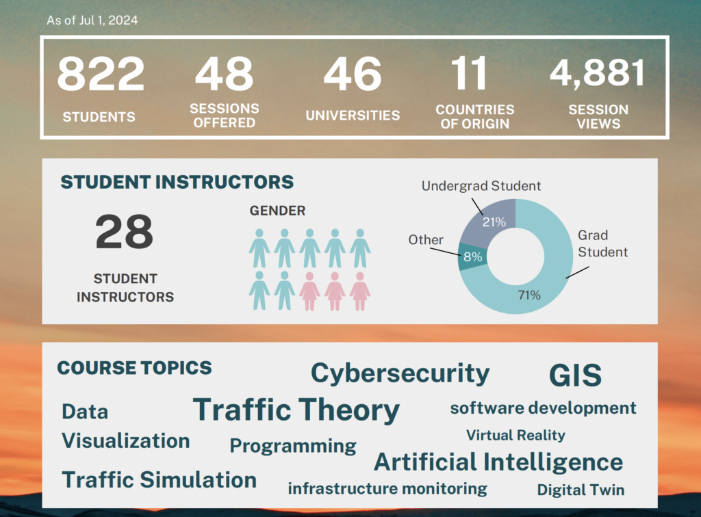
Since Fall 2020, the Student Learning Hub has offered a variety of courses, taught by a range of experts in the transportation field. Over the course of 4 years, we have offered 48 sessions and attracted 822 students, across 46 universities, from 11 countries internationally. We worked with agency and industry partners to deliver programs, provided our students with access to researchers and professionals to learn both professional and academic skills. To learn more about past programs, or to request recordings of past lectures, email us.

In addition to training and skill building, the Student Learning Hub provides our graduate students to explore career options and build a professional network through our What’s the Chatter? event series, which connects students directly to industry partners. 

In this series, C2SMARTER students interview important industry figures to discuss matters of innovation, research, design, and technological disruption in the transportation sphere.

Past Programming

  • Instructor: Saul Bezner, Carnegie Mellon University
  • Hands-on exercise: Yes
  • Beginner level: No prior experience required. Basic GIS knowledge is preferred.
  • Schedule: Friday, March 8th, 12:00 pm -1:00 pm ET
  • Description: Are you interested in public policy? Perhaps there’s an issue in your community that you want to investigate or raise awareness for. Geospatial analysis is an excellent tool that can be applied to countless areas, from independent advocacy to high level policy. In this course, participants will hear a brief presentation concerning the effects of increasing freight traffic on community health in Southwestern Pennsylvania. Participants will then be introduced to the ArcGIS analysis tools that were used to create the presentation, including the Buffer, Clip, Summarize Within, and Spatial Join tools. No prior knowledge of these tools is needed–just and eagerness to learn! The presenter will introduce tools in ArcGIS Pro 3.1. The concepts discussed can also be applied to open-source software packages like QGIS, although the platforms themselves are different.
  • Recording Link: Here
  • Instructor: Ziyue Feng, New York University
  • Hands-on exercise: Yes
  • Beginner level: No prior experience required.
  • Schedule: Thursday, March 28th, 12:00 pm -1:00 pm ET
  • Description: Databases have become indispensable in our daily lives. In this one-hour session, we’ll cover the fundamental concepts of database systems and Structured Query Language (SQL). Additionally, we are going to have a hands-on session with SQL to help you become familiar with data extraction techniques.
  • Recording Link: Here
  • Presentation Slides: Here 
  • Chinook Database Download Link: Here
  • DB Browser for SQLite: Here
  • Instructor: Hannah Bonestroo, New York University
  • Hands-on exercise: Yes
  • Beginner level: No prior experience required. Basic website development knowledge is preferred.
  • Schedule: Thursday, April 18th, 12:00 pm -1:00 pm ET
  • Description: In this one-hour course, you will learn how to create a basic interactive online map using JavaScript, HTML, and CSS. These essential web development tools will allow you to showcase your research findings to a wider, non-technical audience. While this course will only cover the very basics, we will discuss how further mastering these tools can open up a world of opportunity for data visualization.
  • Recording Link: Here 
  • Demo Materials: Here
  • Instructor: Komal Gulati, North Carolina A&T State University
  • Hands-on exercise: Yes
  • Beginner level: Basic GIS and AI knowledge is preferred.
  • Schedule: Thursday, April 25th, 1:00 pm -2:00 pm ET
  • Description: Geospatial Artificial Intelligence (GeoAI) offer transformative capabilities for handling and analyzing geospatial data. This course will introduce you to the essentials of GeoAI, including its significance and range of applications, followed by a detailed walkthrough of the ArcGIS Pro environment and the GeoAI Toolbox. You’ll gain hands-on experience in leveraging deep learning for geospatial analysis, from preparing training datasets to executing model inferencing, culminating in a practical exercise aimed at detecting infrastructure vulnerable to landslides in the island of Grenada.
  • Recording Link: Here 

Instructor: Omar Hammami, New York University

As blockchain continues to grow in popularity, another type of distributed ledger is gaining traction as well: enterprise grade distributed ledgers. This session will give an overview on enterprise grade distributed ledgers, answering the questions on how they work, and when to use them. A tutorial using Hyperledger Fabric will also show how we can create and interact with our own traffic specialized distributed ledger, to demonstrate a real use case.

Access the recording.

Instructor: Yu Hu, New York University

The Introduction to Cybersecurity and its application in Transportation will help you to discover essential knowledge, skills, key elements and topics in cybersecurity. We will briefly discuss the history of security analysis of modern automobiles and the need for cybersecurity including typical threats and potential solutions.

Access the recording.

Instructor: Srushti Rath, New York University

In this session, students learned the basics of text representation in natural language processing (NLP) and various state-of-the-art NLP techniques for (semantic) textual similarity tasks. The session walked through data preparation and processing steps with language modeling tools in Python (e.g., Doc2Vec, Sentence-BERT) for computing text/document similarity and discussed several practical applications of such NLP techniques in transportation related downstream tasks.

Access the recording.

Instructor: Chenxi Liu, University of Washington

This session provided students with a foundational understanding of Computer Vision (CV) technology including the basic knowledge about image processing. Also, a simple Convolutional Neural Network (CNN) was mentioned in the session to demonstrate traffic sensing based on image data. The session required basic knowledge about python.

Access the recording.

Instructor: Alex Wen, New York University

This series provided a brief introduction to ArcGIS by teaching the basics of geographical visualization and preliminary spatial analysis. The first session introduced the user interface and taught the basics of map design; the spatial relationship between pedestrian traffic and pavement quality was explored. The second taught students about the basics of data management (e.g., data cleaning, attribute filtering) and briefly introduced ArcPy (Python in ArcGIS).

Instructor: Zhengbo Zou

This session provided students with a foundational understanding of the use of virtual reality in construction, with a focus on construction safety at work zones. It focused on state-of-the-art implementations of virtual reality in the construction domain, and how it could be used to carry out user experiments when dangerous situations are to be simulated for construction safety studies. Finally, students learned through example of how to create a virtual reality model from an existing building information model.

Register for access to video recording.

Instructors: Fan Zuo & Sha Di

Traffic simulation is the mathematical modeling of transportation systems through the application of computer software to better help plan, design, and operate transportation systems. In this course, students got to know the extensive functions of an open-source, highly portable, microscopic, and continuous road traffic simulation package, Simulation of Urban MObility” (SUMO), which is designed to handle large road networks.

Register for access to video recording of Session 1.

Register for access to video recording of Session 2.

Register for access to video recording of Session 3.

Instructor: Suzana Duran Bernardes, NYU

This session was intended for newcomers to data visualization. The program demonstrated best practices for data visualization and data storytelling with examples from real world cases. Students generated powerful visualizations and dashboards of common data analyses that will help people understand and make decisions based on their data.

Register for access to video recording.

Instructor: Gyugeun Yoon, NYU

Transit systems are essential to modern urban communities to fulfill the travel demand within or between regions. This course covered two aspects of how transit systems have developed: 1) a description of different types of transit operation systems, and 2) an introduction to how to use the open-source simulation (written in MATLAB) shared with the public via Github (https://github.com/BUILTNYU/FTA_TransitSystems).

Register for access to video recording of Session 1.

Register for access to video recording of Session 2.

Instructor: Chan Yang, Rutgers University, Rutgers Infrastructure Monitoring and Evaluation (RIME) Group

Nowadays, bridges are everywhere, establishing connections between different lands and expediting communications. In the field of bridge engineering, designing a new bridge and evaluating an existing bridge are equally important. This session provided students with a fundamental understanding of structural health monitoring (SHM), with a focus on the modeling technique using Abaqus software.

Register for access to video recording.

Instructor: Dr. Yueshuai (Brian) He, New York University

This workshop provided a detailed introduction to the MATSim-NYC model developed by C2SMART Center and taught students how to extend the base model to incorporate new scenarios as well as how to duplicate the development of the model to other cities. The MATSim-NYC model is a city-scale simulation test-bed to evaluate emerging technologies and policies with a common platform. Participants will gain hands-on example data and scripts from the model and practice input preparation and output analysis.

Request access to video recordings.

Instructor: Suzana Duran Bernardes, New York University

The session introduced learners to data science through the Python programming language and fundamental programming concepts including data structures, basic operations in Python, Pandas library for data analysis, and Matplotlib for data visualization. Students used Jupyter Notebook to create their own programs for data retrieval, processing, and visualization.

Register for access to video recording of Session 1.

Register for access to video recording of Session 2.

Instructor: Zilin Bian, New York University

This session will provided students with a foundational understanding of machine learning models (isolation forest, decision tree, neural network etc.) as well as demonstrate how these models can solve complex problems for smart cities. 

Register for access to video recording.

Instructor: Jingxing Wang, University of Washington

This session introduced approaches to collect open-sourced transportation data for related research. Students used Google API travel time data collection as an example to demonstrate how such real time travel time data was collected and used for traffic performance analysis in the greater Seattle area during the COVID-19 pandemic.

Register to access to video recording.

Instructor: Yubin Shen, Research Engineer
Hands-on exercise: Yes
Beginner level: No prior experience required.
Schedule: February 25, 2022 | 2:00 PM – 3:00 PM ET

This course will go through the most popular Amazon Web Services (AWS) with two small projects: 1) build a static website using AWS Simple Storage Service (S3), and 2) build a WordPress website using AWS Elastic Computing (EC2) and Relational Database Service (RDS).

Watch video recording. 

Instructor: Murat Barlas, New York University
Hands-on exercise: Yes
Level: No prior experience required, but knowledge of Python is preferred.
Schedule: March 4, 2022 | 2:00 PM – 3:00 PM ET 

This course is for students who want to learn about interactive data visualization. Students will learn the basics of creating an interactive data dashboard using Python. Data cleaning and formatting methods will be introduced using the pandas and NumPy libraries. Students will learn through examples of how to create a dashboard using a sample dataset using Dash Plotly.

Watch video recording.

Instructor: Chenxi Liu, University of Washington
Hands-on exercise: Yes
Level: Basic knowledge of Python and Computer Vision is preferred.
Schedule: April 15, 2022 | 1:30 PM – 2:30 PM

As a follow-up learning of the previous learning hub course, “How to Build a Toy Computer Vision (CV) Model,” this course will introduce relatively more advanced object detection and tracking knowledge using computer vision techniques. This course will introduce the principle of object detection through Convolutional Neural Network (CNN) and realize your first object detection model. The course will cover the contents about the common tools for object detection, data labeling, and model training.

Watch video recording.

Instructor: Yu Tang, New York University
Hands-on exercise: Yes
Level: No prior experience required.
Schedule: April 1, 2022 | 1:00 PM – 2:00 PM ET

Dynamic flow networks are a class of useful models for a variety of engineering systems including transportation systems, production lines and communication networks. This session will introduce its basic concepts, mathematical modeling and control strategies. The application will be illustrated with ramp metering, a typical strategy for freeway management.

Watch video recording.

Instructor: Matthew Maggio, Software Engineer

Hands-on exercise: Yes

Level: No prior experience required.

Schedule:  April 22, 2022 | 1:00 PM – 2:00 PM ET

Mobile development can seem overwhelming at first, however Google’s Android platform offers a learning experience tutored toward beginners as well as a plethora of examples to get started. In this course, we will look at the basics of Android Studio and review the fundamentals of the Android environment to create a simple Android application.

Watch video recording.

  • Instructor: Hector Landes, New York University
  • Hands-on exercise: Yes
  • Level: No prior experience required.
  • Schedule: Wednesday October 26, 2022, 1:00pm – 2:00pm
  • Description: This course will be a general introduction to how to use open data for transportation projects. It will start with a short lecture to introduce open-data sources and software to use for data engineering with a focus on demographic, traffic, economic, and safety data. The second part will be a tutorial on how to retrieve data from these sources, how to clean them, manipulate them, and finally visualize them. Finally, this course will also cover how to troubleshoot during data pre-processing and how to overcome an error in either the code or the data. Hands-on exercises on how to use Excel, Tableau, Jupyter Notebook, and QGIS to process the data will be presented.

Resources

  • Instructor: Talha Azfar, Ph.D Candidate at UTEP
  • Hands-on exercise: Yes
  • Level: No prior experience required.
  • Schedule: Friday, November 4, 2022, 1:00pm – 2:00pm
  • Description: Realistic digital geographical models of real-world locations are a necessary starting point for digital twin applications, especially for simulation and visualization. This presentation will cover efficient and convenient procedures to create a 3D digital model of the UTEP campus along with the road network on the Unreal Engine project for CARLA, a driving simulator. This can enable applications like computer vision, traffic simulation, and autonomous driving experimentation.  It can serve as a testbed for connected sensors and synchronized databases towards a complete digital twin.

Resources

  • Instructor: Zhanhang Li, Rutgers University
  • Hands-on exercise: Yes
  • Level: No prior experience required.
  • Schedule: Wednesday, November 11, 2022, 1:00pm – 2:00pm
  • Description: This course will provide students with a foundational understanding of machine learning models and degradation processes. With the bridge degradation modeling case study, students will learn about different types of neural networks, their strengths, and context of application. Case studies and live demos will be provided using Artificial Neural Network (ANN) (Multilayer Perceptron [MLP]) and Convolutional neural network (CNN) for bridge rebar degradation modeling.

Resources

  • Instructor: Hella Alnajjar, New York University
  • Hands-on exercise: Yes
  • Beginner level: No prior experience required.
  • Schedule: Wednesday, November 18, 2022, 1:00pm – 2:00pm
  • Description: This course is for students who want to learn how to conduct, distribute, and analyze a survey-based study using Qualtrics, a powerful online survey tool, for research purposes. The lesson will include hands-on exercises on how to create sets of questions of various types, import data, set up a display or skip logic for a question, and how to effectively visualize, export and analyze the data collected.

Resources

  • Instructor: Fan Zuo, New York University

  • Schedule: Friday March 10, 11:00am-12:00pm

  • Description: (Yes, this is written by ChatGPT) In this course, you will learn about ChatGPT, a state-of-the-art language model developed by OpenAI. You will gain an understanding of how ChatGPT works and how it can be used to generate human-like text, answer questions, and perform various natural language processing tasks. Through hands-on activities and live demos, you will also get to apply ChatGPT to real-world problems and understand its advantages as well as limitations. Whether you are a student, developer, or researcher, this course will provide you with a solid foundation in the exciting field of AI and natural language processing.

  • Watch the recording: ChatGPT 

  • Instructor: Zilin Bian, New York University

  • Schedule: Friday March 24, 12:00pm-1:00pm

  • Description: Graph Neural Networks (GNNs) are a powerful tool for analyzing and processing graph-structured data. This course covers the basics of GNNs, including graph convolutional networks, graph attention networks and graph wavelet networks, including how they work and how to implement them. The session aims to provide a solid understanding of GNN modeling for machine learning practitioners, data scientists, and anyone interested in AI advancements.

  • Watch the recording: Graph Neural Networks

  • Instructor: Lukelo Thadei Luoga, New York University Abu Dhabi

  • Schedule: Friday March 31, 1:00-2:00pm

  • Description: In this hands-on course, you’ll learn how to use Unity 3D to build 3D models of road networks. You’ll start with the basics of Unity 3D, including its interface, GameObjects, components, and scripting. From there, you’ll dive into building 3D models of road networks, covering elements such as roads, buildings, and terrain. 

  • Watch the recording: Unity 3D

  • Instructor: Samiha Tasnim, North South University

  • Hands-on exercise: Yes

  • Beginner level: No prior experience required.

  • Schedule: Friday April 14, 10:00am-11:00am

  • Description: Rayyan is a free web tool that aims to help researchers work on systematic reviews by accelerating the process of screening and selecting articles. Besides, the Preferred Reporting Items for Systematic reviews and Meta-Analyses (PRISMA) checklist is an extensively used tool for reporting systematic reviews, which strives to create transparent, credible, and reliable research results. This course intends to cover the fundamentals of using Rayyan and PRISMA, why, and how to utilize them to kickstart your pathway toward research.

  • Watch the recording: Systematic review

NOTE: THIS EVENT HAS BEEN POSTPONED. CHECK BACK FOR UPDATES AS THEY ARRIVE.

  • Instructor: Shajnush Amir, North South University & University of Twente

  • Hands-on exercise: Yes

  • Beginner level: No prior experience required.

  • Schedule: Friday April 28, 11:00am-12:00pm

  • Description: In this course, you will learn how to harness the power of OSMnx, a Python library for extracting and visualizing Open Street Maps data. Through hands-on exercises, you will gain practical experience in using OSMnx to model and simulate projects and have a solid understanding of this Python library and be able to apply OSMnx to real-world problems.

  • RSVP: https://nyu.zoom.us/meeting/register/tJMpf-CvrjwvGNYDTZgj9w7IwN9bhLoKjZUp

  • Instructor: Haggai D. Davis, III, New York University

  • Hands-on exercise: Yes
  • Beginner level: No prior experience required.
  • Schedule: Friday Oct 13th, 11:30am-12:30pm

  • Description: Machine learning is an incredibly broad term that encompasses a lot of different algorithms which can be applied to solve a variety of problems.  Neural networks are one category of ML algorithms which consist of layers of nodes (or neurons) which will activate to transmit information when certain thresholds are met. RNNs and CNNs are subclasses of neural networks whose differing structures allow for the analysis of different types of datasets, usually things like time-series and pattern-recognition, respectively.

  • Recording Link: Here

  • Instructor: Vidisha Chowdhury, University of Pennsylvania & Philippe Schicker, Carnegie Mellon University

  • Hands-on exercise: Yes

  • Beginner level: No prior experience required.
  • Schedule: Friday October 20th, 12-1 pm

  • Description: Google Earth Engine (GEE) and other cloud-based geospatial analysis platforms can be powerful tools for data scientists and researchers to analyze vast amounts of satellite imagery and geospatial data. In this one-hour introductory course, we are going to provide you with a basic understanding of GEE, contrast it to traditional geospatial techniques, and highlight how GEE can be used for applications such as environmental monitoring, land cover classification, and more.

  • Recording Link: Here

  • Instructor: Yuhao Liu, NYU Shanghai

  • Hands-on exercise: Yes

  • Beginner level: No prior experience required.
  • Schedule: Friday Oct 27th, 12-1pm

  • Description: This course is designed to equip the audience with the basic knowledge and skills necessary to navigate the world of high performance computing (HPC) and leverage IBM’s CPLEX optimization studio for tackling complex optimization challenges. In this course, you will learn 1) how to run computation tasks on HPC clusters; 2) how to solve optimization problems using the C++ API of CPLEX; and 3) how to deploy and run CPLEX programs on HPC clusters for large-scale optimization models and/or parallel optimization algorithms. 

  • Recording Link: Here

  • Guest: Prof. Gabriela Gongora-Svartzman, Carnegie Mellon University

  • Date: Wednesday, Nov 8th, 4pm-5pm

  • Description: In this insightful fireside talk, we explore the synergy between data-driven careers, industry, and education, emphasizing the transformative power of data literacy in decision-making. Prof. Gongora-Svartzman will provide insights on maximizing the value of academic and experiential opportunities, bridging the gap between education and real-world applications, and offering guidance on post-graduation career transitions. Additionally, Prof. Gongora-Svartzman will delve into the pivotal role of technologists in building public trust through technology in the public sector and promoting tech for social good. She will address the critical importance of ethical data analysis, highlighting the role of data storytelling and visualization in projects. Join us to shape a future where data-driven professionals play a vital role in fostering positive societal impact.

  • Bio: Prof. Gongora-Svartzman serves as an Assistant Teaching Professor for Heinz College of Information Systems and Public Policy, Carnegie Mellon University, where she teaches various courses, including Exploratory Data Analysis and Visualization with Python, Machine Learning Foundations with Python, and Data Analytics with Tableau. She also holds the role of faculty advisor for capstone projects for various graduate programs. Before joining CMU, she was an Adjunct Instructor at Stevens Institute of Technology’s Business Intelligence and Analytics Program and an Adjunct Associate Faculty at Columbia University’s Applied Analytics Program. Prof. Gongora-Svartzman’s research focuses on Urban Informatics, Data Visualization for Decision Making, and Resilience and Social Perception. Her work uniquely bridges technical service performance with human perceptions, covering areas like disaster preparedness through social media analysis, smart city service quality, social equity movements, transportation services, and decarbonization strategies. She actively contributes to the field as a member of INFORMS, leading sessions on diversity, equity, and inclusion and serving in various leadership roles. Beyond her academic pursuits, she champions women in STEM, diversity, equity, and inclusion in computing and mentors students in data competitions. She has also served as chair of the Early Career Teachers Network (ECTN 2021 and 2022), Secretary for Women in OR/MS (2021), current VP of Communications for Women in OR/MS (2022) and has been a mentor for the Women in OR/MS Mentorship program for 2019-2021.
  • Recording Link: Here

  • Instructor: Vivian Otieno, Texas Southern University
  • Hands-on exercise: Yes
  • Beginner level: No prior experience required.
  • Schedule: Friday November 10th, 12-1pm
  • Description: Essentials of Data Acquisition for Transportation Analysis involves the collection, processing, and analysis of data about traffic patterns, vehicle movements, and other factors that can be useful in the transportation industry. This course will cover types of data acquisition systems, the technologies used in data acquisition, the advantages and disadvantages of data collection systems, and how the collected data is used in the transportation industry to improve the system and make it better.
  • Recording Link: Here

Student Hub Coordinators

Jingqin Gao

Jingqin Gao

Assistant Director

Lizzie Pohl

Lizzie Pohl

Research Project Manager